news
Engineering failures likely caused dam breaks in South Carolina during record flooding
Primary tabs
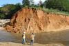
A team of scientists led by the School of Civil and Environmental Engineering’s Hermann Fritz has just returned from a four-day reconnaissance mission in South Carolina assessing damage after record-breaking rainfall flooded large swaths of the state.
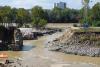
As Hurricane Joaquin passed offshore and shoved unprecedented amounts of rain into the state, rivers surged and dams failed, releasing torrents of water downstream. Fritz’s team is trying to find out just how high the water rose and why some of those dams gave way.
“From a sustainable and resilient infrastructure point of view, the cause of the numerous dam breaches needs to be investigated. The fieldwork allowed us to measure high water marks on the river banks both upstream and downstream of the dams to determine the hydraulic loading on the mostly earthen dams and analyze their performance,” Fritz said.
“Unfortunately, several dams failed prior to being overtopped pointing at geotechnical engineering design or maintenance failures.”
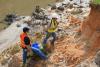
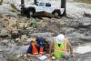
Fritz led several Georgia Tech graduate students, colleagues from Clemson University, and partners from Geosyntec Consultants and the Federal Energy Regulatory Commission on the four-day survey this week, taking soil samples and assessing damage. The trip was organized by the Geotechnical Extreme Events Reconnaissance (GEER) Association with support from the National Science Foundation.
The samples collected by the graduate students head to labs at Georgia Tech and Clemson for analysis so the scientists can better understand the soil’s characteristics.
Fritz said some dams performed flawlessly, which will provide valuable lessons-learned. But the ones that failed resembled another notorious flooding event.
“The South Carolina flooding was characterized by local dam failures of mostly earthen dams, which was reminiscent to the aging infrastructure and poorly maintained levees in New Orleans during Hurricane Katrina 10 years ago,” said Fritz, who has done extensive work along the Gulf Coast where Katrina came ashore. “In both cases, earthen dams or levees were aging and poorly designed with soils of limited strength, resulting in breaches prior to reaching their design heights or being overtopped [by water]. Both events provide textbook examples of dam failures prior to floodwaters reaching the crest height and also due to overtopping.”
“It was amazing how the dam failures were concentrated in the greater Columbia area in contrast to the reserves downstream of Columbia, where freely meandering rivers flooded wide swaths of marshland, but provided few engineering failures,” he said.
Fritz said the team’s data also will help forecasters refine their models, which he said are based on 75 years worth of data and tend to underestimate a disaster like this flooding.
“The maximum rainfall five-day total reached two feet, exceeding even rainfall totals during the direct hit of Hurricane Hugo in 1989 on Charleston,” Fritz said. “The NOAA precipitation statistics will have to be redefined after this event, and it raises serious questions about how meaningful they are going forward while facing climate change.”
The research team will publish detailed observations and findings on the GEER website in the coming weeks. The team also included Ronald Andrus and graduate student Barnabas Bwambale, Clemson University; Jeremy Varner, Federal Energy Regulatory Commission; Robert Bachus, Thomas Bristol, Brandon Mogan, Melissa Setz, Glenn Rix, and Njoroge Wainaina from Geosyntec Consultants.
Status
- Workflow status: Published
- Created by: Joshua Stewart
- Created: 10/16/2015
- Modified By: Fletcher Moore
- Modified: 10/07/2016
Categories
Keywords
User Data