news
Leonard and Bullen Win 2017 Georgia Tech GIS Day Student Competition
Primary tabs
Matthew Leonard, pursuing a Masters in Geographic Information Science & Technology, and Lucy Bullen, an undergrad with the School of Industrial & Systems Engineering, won this year’s Georgia Tech GIS Day Student Competition. Entries were hung in the Crow’s Nest and on November 15 winners were determined by popular vote.
Each year, GIS Day produces a number of student entries, some more serious-minded than others. This year’s entries and winners were no exception. Matt tackled inequality and gerrymandered school districts in Gwinnett County, while Lucy mapped a Baby Driver-inspired heist plan of Washington DC.
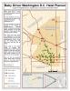
“I began to put together this map after watching the movie Baby Driver,” Lucy explained. “That day, when I browsed through potential GIS data sets, I found one with all the bank locations in Washington D.C. and the thought clicked. The idea for the map was set as a heist scenario.”
For Matt, there was a larger problem to understand. “Anecdotal evidence suggested that school districts in Gwinnett County, Georgia, seem to be “gerrymandered” to include or exclude certain areas based on housing type/density and thus income and race, a pattern that may help perpetuate socioeconomic inequality,” Matt explained. That larger problem required a much more complicated methodology. “I'd say the main difficulty in this project was that I had data on a variety of indicators at the census block group or tract level, and I wanted to map those same indicators by school zone, so I had to figure out how to transfer them to a different geographical unit.”
At the end of the day, both students produced great work.

Summary
Matthew Leonard, pursuing a Masters in Geographic Information Science & Technology, and Lucy Bullen, an undergrad with the School of Industrial & Systems Engineering, won this year’s Georgia Tech GIS Day Student Competition.
Status
- Workflow status: Published
- Created by: bdiacetis3
- Created: 11/26/2017
- Modified By: bdiacetis3
- Modified: 11/26/2017
Categories
Keywords
User Data