news
Broad-based Georgia Tech Research Aims to Make Transportation More Efficient
Primary tabs
Rising concern about fuel prices and the environmental impact of transportation had led to a broad range of research activities at the Georgia Institute of Technology. Making transportation of all kinds more efficient is the focus of the cover story in this issue of Research Horizons magazine.
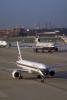
Continuous Descent Arrivals: Atlanta Flight Test Evaluates Technique for Saving Fuel and Reducing Noise in Airliners
Airline passengers arriving in Atlanta on early morning “redeye” flights during the past few months may have noticed something different during their descent to the runway. Instead of the typical sound of engine power rising and falling as the aircraft descended in a series of level flight steps, they may have noticed a quieter arrival – without the steps.
The changes were part of Georgia Tech’s flight-testing of “continuous descent arrivals,” a procedure designed to save fuel and time while producing environmental benefits by reducing both noise and emissions. Involving more than 600 flights, the Atlanta study was done in collaboration with the Federal Aviation Administration (FAA), FedEx and Atlanta’s two dominant air carriers: Delta Air Lines and AirTran Airways.
The continuous descent arrival procedure has already been studied at Louisville and Los Angeles airports. Proponents hope the 90-day test at Hartsfield-Jackson Atlanta International Airport – currently the nation’s busiest airport – will move the concept one step closer to nationwide implementation. Estimates suggest that continuous descent arrivals could save a large airline as much as $80 million per year in fuel costs alone.
“In commercial aircraft, we see anywhere between 300 and 1,000 pounds of fuel saved for each arrival,” said John-Paul Clarke, director of the Air Transportation Laboratory at Georgia Tech and an associate professor in the Daniel Guggenheim School of Aerospace Engineering. “With fuel cost at $3 per gallon, that would amount to as much as $600 per arrival and could really add up for the airlines at a time when they need all the savings they can get.”
Because aircraft engines don’t throttle up and down during a continuous descent arrival, there are also significant reductions in noise and emissions. Keeping engines at idle power can cut emissions of nitrogen oxides by nearly a third, and reduce noise by 6 decibels along certain portions of the flight path – both significant reductions that would improve the environment in the vicinity of airports.
And the technique could cut two minutes off the approach and landing portion of a flight. While that doesn’t seem like much, it could result in more efficient utilization of aircraft and reductions in flight times for crews.
Continuous descent arrival is one in a series of improvements aimed at creating the next generation of air transportation technologies. The goal is to redesign the airspace to allow future airliners to travel the most efficient paths to their destinations.
Though the final numbers from the Atlanta evaluation won’t be known for several months, the potential savings have been demonstrated by more than 60,000 landings at Los Angeles with a continuous descent arrival technique developed by Georgia Tech. But adopting the procedure throughout the airspace system won’t be easy. Safety considerations must be paramount, and there are a number of optimization challenges caused by widely varying aircraft types, wind conditions and airport configurations.
“Imagine a line of aircraft descending through a long tube that’s fixed laterally and limited vertically to be within a narrow band,” explained Clarke. “If each airplane were like a ball with a different coefficient of friction, then when you put the balls in the tube at equal intervals, they would begin to catch up with one another. The ball with the lower coefficient would tend to catch up with the ball with a higher coefficient. That’s something that we have to work very hard to avoid.”
While the risks of getting aircraft too close are obvious – and governed by FAA rules on minimum spacing – too much spacing between landing aircraft can waste time and reduce airport throughput.
“The goal is to design a procedure that allows the aircraft engines to throttle back to idle power at the point of initial descent and to remain at idle power along the flight path to the runway as long as possible,“ Clarke added. “We have figured out how to put altitude and speed constraints along the flight path so they can stay at idle power as long as possible while achieving the required minimal spacing at the runway threshold.”
Determining those constraints requires detailed knowledge of the performance of each aircraft type in use. Clarke and his research team have obtained performance data for most Boeing aircraft, as well as some of those manufactured by Airbus. Based on the performance data, they have simulated the operation of each aircraft type under varying wind and weight conditions.
The researchers have also modeled variation in pilot behavior, because small differences in when flaps are deployed and landing gear lowered create variations in speed, which affect aircraft spacing.
Arrivals would be customized for each airport, taking into account wind and traffic patterns. And because the spacing between aircraft is determined well before they arrive at their destinations, adoption of the technique will require changes in the nation’s air traffic control system.
“The air traffic control system currently isn’t designed to allow the kind of fine-tuning we need, but I’m very optimistic about being able to change that,” said Clarke. “Throughout all the areas, the FAA and the airlines, there is a growing acceptance that this is a solution. We have been able to do the analysis, the flight-testing and the number crunching to show that it can be done.”
Clarke, who began the research at the Massachusetts Institute of Technology before joining Georgia Tech in 2005, believes the cost savings will ensure adoption of continuous descent arrivals. He compared the technique to the adoption of fuel-saving winglets, small vertical attachments that have replaced traditional wingtips on many aircraft.
“For years people knew that winglets provided better performance, but it costs money to install them,” he added. “When fuel got more expensive, airlines started installing winglets because the savings justified the costs. The benefits of continuous descent arrival may also take some time to be realized.”
Written by John Toon
Developing New Systems to Monitor Traffic
Imagine getting into your vehicle and entering your destination into a small device that continuously sends your speed, location and travel path to a traffic monitoring station. By combining your information with data from other vehicles, motorists could receive real-time notifications of tieups and slowdowns in traffic on any road, from the largest interstate to the smallest dirt lane. The device could then display a map depicting the best route around congestion to your destination.
“We’re investigating how to develop such a system, which will be the future generation of intelligent transportation systems,” says Michael Hunter, an assistant professor in Georgia Tech’s School of Civil and Environmental Engineering (CEE).
Hunter is working on this research with Richard Fujimoto, Regents’ Professor and chair of the College of Computing Computational Science and Engineering Division; Christos Alexopoulos, associate professor in the H. Milton Stewart School of Industrial and Systems Engineering; Randall Guensler, CEE professor; and Frank Southworth, CEE principal research scientist and Oak Ridge National Laboratory senior research staff member. These eff orts are being funded by the National Science Foundation’s Emerging Frontiers in Research Innovation program.
“By allowing motorists to be more active and participate in the traffic monitoring system by providing real-time data to the traffic centers, officials could build a picture of current and future traffic flow and actively manage that traffic with much lower infrastructure cost than is done today,” says Fujimoto.
The research team envisions that each vehicle would contain a computer that collects real-time information and rapidly produces reliable forecasts of the future traffic in its local area. Using a concept called ad hoc distributed simulations, each vehicle’s simulation of a portion of the network would be combined to create a more complete picture of the entire network. This type of system would allow offi cials to know what’s happening on side roads and not just on the camera-equipped freeways.
The researchers are currently investigating how to send information from each vehicle to a roadside server, which could involve transmitting it wirelessly from vehicle to vehicle until it reaches the server. They are also developing communications protocols to determine which information to collect and pass to the next vehicle and how to handle the databases in each vehicle. Field tests could begin in 2009.
“The benefit of this type of system is that it tells traffic officials where a lot of people are headed so that they know what the demand is going to be, which will allow them to start managing for that demand immediately,” explains Hunter.
This material is based upon work supported by the National Science Foundation under Award No. EFRI- 0735991. Any opinions, findings, conclusions or recommendations expressed in this article are those of the researchers and do not necessarily reflect the views of the National Science Foundation.
Written by Abby Vogel
Optimizing Routes and Resources: Georgia Tech Helps Trucking Companies Reduce Costs and Improve Service
As competition increases and shippers raise their expectations for service, trucking companies must optimize their routes and use of drivers, vehicles and facilities.
Researchers in the H. Milton Stewart School of Industrial and Systems Engineering at Georgia Tech are developing models to help optimize driver and equipment scheduling, shipment planning, load consolidation and routing for two carriers – Saia and YRC Worldwide. The companies operate as less-than-truckload carriers, which means they collect freight from various shippers and consolidate that freight to fill trailers for travel to common destinations.
“Tens of thousands of shipments have to be picked up and then dropped off hundreds or thousands of miles away, and we’re studying how all of that freight can best be consolidated and sent through the company’s network of hundreds of facilities to minimize cost and improve service,” said Martin Savelsbergh, Schneider Professor in the School of Industrial and Systems Engineering.
Many less-than-truckload carriers operate with a fixed consolidation and routing plan that they typically repeat every day. But Savelsbergh, along with associate professor Alan Erera, and graduate students, developed a different tactical plan for each day of the week for Duluth, Ga.-based Saia.
“Our results have shown that there is the potential for 5 to 10 percent reductions in line haul costs, which equates to savings of $10 million to $20 million per year, simply by executing a different plan each weekday,” said Erera.
Taking it one step further, the researchers are developing real-time dynamic plans for Saia based on freight information collected each day. While the goals of dynamic planning are to reduce the time required for freight in the system to arrive at destinations and to cut costs, the models developed also consider the future operational cost impact of decisions made today.
For YRC Worldwide, which operates both the Yellow Freight and Roadway carriers, the researchers initially focused their efforts on driver management issues. They developed a computer program that could plan a week’s worth of driver schedules in a matter of minutes, while considering driver constraints and costs.
“Our software can be used to tell companies how many drivers they should have, where the drivers should reside and how they should be dispatched,” noted Erera.
The researchers have also recommended ways to manage YRC’s equipment to minimize the tractor and trailer resources required by the company to effectively serve its customer demands. Results indicate that fleet sizes may be reduced by 10 to 15 percent if resources are moved geographically to where they are needed most at any given time.
“The optimization techniques we’ve developed are applicable for any less-than-truckload carrier and are going to become increasingly necessary in the future to maximize profit and service based on the fixed resources available,” explained Savelsbergh.
Funding for this research was provided by the companies through the Leaders in Logistics program, which is part of the Georgia Tech Supply Chain and Logistics Institute, and by the Alfred P. Sloan Foundation’s Trucking Industry Program.
Written by Abby Vogel
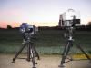
Testing Instruments to Detect Invisible Aviation Hazards
While radar and other existing systems typically warn aircraft pilots of potential weather hazards during flight, they do not detect all possible atmospheric dangers.
“Some hazards can be the most dangerous because pilots’ eyes and radar cannot see them,” says Gary Gimmestad, a principal research scientist in the Georgia Tech Research Institute (GTRI).
GTRI is leading a team of researchers from five universities and research organizations to investigate the feasibility of using an instrument called a forward-looking interferometer to detect several of these invisible hazards during takeoff, cruise and landing. Forward-looking interferometers can detect the presence of the environmental hazards by identifying each hazard’s distinct infrared spectral signature.
With funding from NASA, the researchers are conducting studies to determine the sensitivity of the system for detecting clear-air turbulence, wake vortices, volcanic ash, low visibility, dry wind shear and ice on runways.
A major concern for air navigation is clear-air turbulence because it cannot be seen and is therefore difficult for pilots to avoid. During a January 2008 ground test in Boulder, Colo., the research team evaluated the feasibility of the infrared interferometer to detect clear-air turbulence at a useful distance from the sensor by measuring temperature fluctuations. They also evaluated the turbulence detection and hazard prediction algorithms they developed.
“The measured results corresponded well to the model predictions, and this result was interpreted as a successful detection of mountain waves with interferometric radiometry, which has never before been accomplished,” adds Leanne West, project director and GTRI senior research scientist.
A second field test was conducted in Madison, Wis., in June 2008 to investigate the ability of the instrument to detect wake vortices. This tornado-like turbulence forms behind an aircraft as it passes through the air and can cause problems for any subsequent aircraft following the same flight path.
The researchers were able to resolve what could potentially be a wake vortex about 80 seconds after a DC-9 aircraft passed overhead. If this result can be verified, it would be the first detection of a wake vortex by spectral infrared radiometry, according to the researchers.
The preliminary results from the field tests show that the imaging system is a promising technology to detect many, if not all, of the external hazards. Further research will be completed to determine if the hazards can be detected in-flight with sufficient time-to-alarm for safe maneuvering to avoid the hazards.
The material in this article is based upon work supported by NASA under award number NNX07AN17A. Any opinions, findings, conclusions or recommendations expressed in this article are those of the researchers and do not necessarily refl ect the views of NASA.
Written by Abby Vogel
Modeling Transportation Infrastructure for the Port of Savannah
The Port of Savannah has experienced dramatic growth – 15 percent per year on average since 2002. This trend could necessitate expanding the roads and railroads leading to and from the seaport on Georgia’s coast. To help guide these infrastructure decisions, researchers at the Georgia Tech Research Institute (GTRI) have developed models that show how freight moves on roads and railroads from the Port of Savannah to the rest of the nation.
Researchers at Georgia Tech have developed models to show how freight moves on roads and railroads from the Port of Savannah. (Click image for high-resolution version. Credit: Georgia Department of Economic Development)
“We are developing models that can answer questions about the local and downstream impacts of growth in port operations, port infrastructure or local infrastructure on the larger system,” says Michael Rodgers, a GTRI principal research scientist.
Rodgers is working on this project with GTRI principal research engineer James McMichael, civil and environmental engineering assistant professor Michael Hunter, and graduate students Christopher Puglisi, Thomas Wall, Franklin Gbologah and Lakshmi Peesapati.
With data from the Logistics Innovation Center and funding from GTRI’s independent research and development program, the models aim to help transportation organizations plan for corresponding growth in rail and highway systems. The models can reveal bottlenecks in the transportation network and determine where money would best be spent to improve the transportation infrastructure.
“Transportation organizations and governments have very limited resources, so our models will tell them what types of improvements give the most bang for the buck,” adds Rodgers. “It is so much quicker, easier and less expensive to change the infrastructure in a computer than it is to change the infrastructure on the ground.”
With the models, the researchers can examine many ‘what-if’ scenarios – such as the impact of new technologies, a high-speed rail line, truck-only lanes or the development of a regional freight corridor. In addition to studying proposals from a technical perspective, the researchers are also investigating the environmental impact of the scenarios based on energy consumption and vehicle emissions.
Currently, the model includes the Port of Savannah, railways from Miami to Washington, D.C., and west to Chicago, and highways from Savannah west to Atlanta. The researchers plan to expand the model to include ports in Charleston, S.C.; Norfolk, Va., and Jacksonville, Fla., and highways throughout the southeastern United States.
“Our models may help determine improvements that will allow freight moving through the Port of Savannah to reach its final destination faster, which could make the port even more attractive to shippers and improve the economy in Georgia,” explains McMichael.
Written by Abby Vogel
Lane Use Management: Monitoring Driving Behavior to Improve Highway Efficiency
Randall Guensler, a professor in the Georgia Tech School of Civil and Environmental Engineering, studies transportation efficiency in metropolitan areas.
His current work focuses on close monitoring of real-world driving behavior. The goal: find ways to improve traffic flow by maximizing the use of existing highways.
The vehicle-activity data being monitored are useful, he explains, not only for evaluating travel behavior, but also for studying traffic operations, safety, and environmental impact. Such data can help guide decisions affecting transportation planning and environmental policy analysis.
“Many experts now believe that actively managing lane use can provide greatly improved service without having to construct extra lanes,” Guensler said. “These managed-lane strategies can be implemented for minimal cost, especially when compared to the land and construction cost, the traffic problems and the demolition issues involved in building new roads.”
Guensler and his team are involved in two major projects directly associated with transportation efficiency and managed-lane approaches:
- Commute Atlanta is a four-phase project that examines how monetary incentives, often called value pricing, can influence driver behavior. The $2.3 million joint project, sponsored by the Federal Highway Administration and the Georgia Department of Transportation (GDOT), is also collecting vehicle-use and demographics data useful in studying highway safety and air quality, as well as traffic flow.
- The Congestion Pricing Project, sponsored by the GDOT, uses a variety of techniques including focus groups to collect consumer opinion and other data on lane-management approaches such as value pricing.
The benefits of controlling lane use through value pricing – sometimes called congestion pricing or peak-period pricing – are counter-intuitive, Guensler says. To people sitting in traffic, it looks as if fewer vehicles are flowing through the adjacent limited-access lane because there are big spaces between each car or truck.
“But in fact if you were looking from the top down, you’d see more vehicles going through that lane every hour than in the congested lanes,” he said. “From an engineering standpoint, traffic flow is the product of vehicle speed and traffic density – that is, the speed of the vehicles and how closely are they following each other.”
To look at it another way, he explains, a small hose that’s flowing freeing moves more water than a large hose that’s blocked.
Commute Atlanta’s first two phases, now complete, examined consumers’ response to having a price attached to their travel practices.
The study selected several hundred representative Atlanta households. Using in-vehicle computers and Global Positioning System (GPS) equipment to collect speed, position and engine-operating data, the study pinned down each family’s average travel habits.
Then each household was offered a monetary rebate for each mile it could pare from its monthly total by any means possible: fewer trips, carpooling, using public transportation, biking or even walking.
Guensler says the study’s first two phases have helped establish research guidelines, but results haven’t been definitive. It’s likely that a larger sampling will be needed to produce statistically significant data. However, he adds, the data already collected from 470 vehicles and more than 1.8 million vehicle trips will be useful in ongoing air-quality and safety research.
The third and fourth phases of Commute Atlanta will simulate the impact of travel behavior on real-time congestion pricing – charging less for restricted-lane travel at off -peak periods. The research also includes installing portable devices on delivery and service vehicles to examine the potential effect of congestion pricing and other pricing mechanisms.
As value pricing of lane use becomes a reality, it’s likely to use a variety of monitoring and toll-collection technologies. To avoid congestion-prone toll booths, future approaches could use technologies similar to today’s cruise cards, which employ radio-frequency identification (RFID) to keep track of a driver’s highway usage.
Another approach could involve on-board vehicle-monitoring systems, which would be in-vehicle devices that use GPS and other techniques to monitor and bill drivers for using special lanes.
The Congestion Pricing Project, a study separate from the Commute Atlanta work, was recently completed for the GDOT. In that project, Guensler teamed with co-principal investigator Catherine Ross, who is the Harry West Professor in the Georgia Tech College of Architecture.
Initially, the Congestion Pricing project reviewed new toll-collection technologies, as well as case studies of congestion-pricing projects in other cities. Subsequently, it interviewed experts on congestion-pricing programs and then analyzed local consumer reactions using focus groups comprised of Atlanta-area citizens.
“Our focus group work revealed interesting points, including the fact that income groups that wouldn’t generally use value priced lanes still liked having them available,” Guensler said. “There are times when everyone finds that these lanes are a good economic decision – such as when you’re late for daycare, and you’re facing dollar-a-minute overtime charges.”
Supporting a $110 Million HOV Toll Lane Project
Under a recently announced plan, the state of Georgia will be the beneficiary of $110 million in federal funds to develop HOV toll lanes along Interstate 85 in metro Atlanta.
The Georgia Tech School of Civil and Environmental Engineering (CEE), partnered with the Georgia Department of Transportation (GDOT), will monitor the effects of the high-occupancy toll (HOT) lane implementation. Georgia Tech has been performing research in support of managed-lane projects since 2003.
Georgia Tech’s activities, led by Guensler, have involved several efforts, including technology development, instrumented vehicle-data collection and analysis of the impact of pricing on traffic and emissions. More recently, working with Catherine Ross’ planning team, the researchers have also completed a series of reports for GDOT that summarize expert panel and focus group results on potential consumer response to congestion pricing.
As the work continues, Guensler will oversee a study that will monitor drivers who choose to use the new toll lanes. His team will track changes in congestion levels, household travel behavior and emissions.
Researchers will also identify potential equity issues in a study that will include 700 households, 1,500 personal vehicles and the express bus fleet. The goal will be to assess the actual travel response and emissions changes that result from implementing the toll project.
Guensler and his team are specialists in the development and deployment of in-vehicle devices to monitor motorists’ driving habits.
For the first two phases of the Commute Atlanta study, researchers developed instrumentation that used an onboard computer and GPS equipment to record numerous driving parameters including location, speed, engine functions and mileage. The team monitored more than 1.8 million vehicle trips on a second-by-second basis. A built-in cellular connection sent back accumulated data weekly.
The third and fourth Commute Atlanta phases are using upgraded equipment that allows real-time tracking of vehicle location, speed, mileage and as many as 10 engine parameters in some monitored vehicles.
Guensler and Jennifer Ogle, now at Clemson University, are principals in Vehicle Monitoring Technology, a new company that is now providing monitoring services for vehicle activity and emissions elsewhere in the U.S.
Written by Rick Robinson
Traveling the Road to Sustainability in Transportation
In transportation, efficiency and sustainability are inseparable.
That’s the viewpoint of transportation-sustainability researchers like Adjo Amekudzi, an associate professor in the Georgia Tech School of Civil and Environmental Engineering.
“Transportation performance needs to be evaluated in broader terms than in the past,” Amekudzi says. “A transport system must move goods and people effectively, but it should do so in ways that are environmentally friendly and socially equitable. In the long term, that approach is best for both sustained economic development and quality of life.”
Sustainable transportation, she says, plays a major role in quality-of-life issues. Clearly, the amount of money that both governments and individuals must spend on transportation affects other important expenditures. Air quality and the amount of time that people spend in traffic also figure importantly in quality-of-life perceptions.
To help achieve sustainability, cities need to promote multi-modal transportation systems – those that distribute transportation over several systems rather than relying heavily on highways, Amekudzi says. A good multi-modal transportation system can improve efficiency across the board by giving both businesses and individuals true flexibility in matching their needs to given transport modes.
Amekudzi’s recent research, funded by the National Science Foundation and the U.S. Department of Transportation, has focused on developing sustainability metrics and methods for sustainability planning. She examines the broader picture of transportation and society, including ways to generate alternative scenarios that can improve both travel efficiency and environmental impact.
Analyzing the link between land use and transportation is vital, she says, because usually land use generates the need for transportation. For instance, if most affordable housing is built outside the city center, people will need expanded transit infrastructure to get to jobs, universities and recreation in places where the bulk of these activity centers exist in the city core.
Amekudzi points to mixed-use facilities, like Atlantic Station in midtown Atlanta. Such self-contained developments, which are blends of residential, commercial and recreational development, pack many resources into a small area, reducing the need for outside trips that consume energy.
“I don’t think everybody needs to park their cars, because we already have a substantial infrastructure for vehicles,” she says. “But we need to come to a point where people will see that they have several viable transportation choices. That in turn will help us to reduce our resource and waste footprints, and allow us to continue to improve our quality of life and make measurable movements toward sustainability.”
Written by Rick Robinson
Tackling Complex Issues Affecting Transport Efficiency
Increasing transportation efficiency involves more than optimizing traffic flow and lowering fuel consumption.
Rather, it requires achieving efficiency in a range of areas, including cost, energy, environment and safety, says Frank Southworth, a principal research scientist in the Georgia Tech School of Civil and Environmental Engineering. Southworth has been a principal investigator on more than 50 transportation-planning projects.
“Most big projects tend to be evaluated on travel-time savings, because time is money,” he says. “But a really efficient system tries to minimize all the costs – the obvious ones and the not-so-obvious – of a passenger or a freight trip, while still remaining reliable.”
For example, he says, if a company can move freight quickly but its fuel consumption is becoming prohibitive or safety is suffering, those problems will affect the real cost of doing business.
“Basically in transportation, the rule is – the bigger, the fewer, the cheaper,” Southworth says. “That means a big vehicle that makes fewer trips is more efficient to operate, especially if its loads are kept as large as possible at all times.”
But, he adds, the most efficient method isn’t always the obvious one, and even the big-vehicle/always-loaded rule has exceptions. For example, many power companies have found that dedicated “unit trains” carrying only coal can be the most efficient way to feed power plants. Even though these miles-long trains go all the way back to the mines empty, they turn out to be cheaper to use than general-purpose freight trains.
Similarly, choosing shipping modes – road, rail, ship, barge or even pipeline – also requires close consideration. Railroads and barges, for instance, typically use less fuel than highway vehicles. Yet the cost of transferring goods to trucks for local delivery can eat up those savings, and that can make straight-through trucking a better choice at times.
Often left out of the transportation equation are environmental costs, says Southworth, who is also a senior research and development staff member at Oak Ridge National Laboratory in Oak Ridge, Tenn. It’s in society’s long-term interest, he says, to promote transportation systems that reduce greenhouse gases such as carbon dioxide and ozone-creating pollutants such as nitrogen oxides.
“Environmental damage, safety and energy costs are often called ‘externalities,’ – external to the primary goal of fast and cheap,” he says. “But you don’t want transportation to occur in such a way that increases pollution and consumes energy unnecessarily – and safety should never be compromised.”
To address environmental issues, he says, transportation researchers have turned to “the three-legged stool” – more efficient engines, less-polluting alternative fuels and reduced transportation demand.
“We tend to say that the bottom line is moving people and goods from A to B for the least cost,” he explains. “But the other question is, what does cost really mean?”
Written by Rick Robinson
Advancing Transportation Research in Georgia
Georgia Tech’s Transportation Research Center (TRC) for Freight, Trade, Security and Economic Strength focuses on improving the security and efficiency of the transportation system, with a concentration on international trade, seaport and airport security, and their economic interrelationships and impacts.
Alan Erera, associate professor in the H. Milton Stewart School of Industrial and Systems Engineering, and Chelsea C. White III, H. Milton and Carolyn J. Stewart School Chair and Schneider National Chair of Transportation and Logistics, serve as TRC co-directors.
With funding from the Center, Stewart School associate professor Christos Alexopoulos and professor David Goldsman are developing a suite of simulation software tools for seaport analysis. The current simulation model is based on the Port of Savannah. The goals of this development effort are to help port management and emergency response teams develop and evaluate facility expansion or reorganization plans, recovery strategies to respond to equipment failures, and security-related technologies, and to conduct emergency situation training.
TRC members are also investigating new forms of information technology, such as radio frequency identification, and the ability of such technology to improve the efficiency and security of today’s transportation systems.
“We are examining the impact of increased container security checks on port productivity and the relative trade-off between trying to prevent a major security-related service disruption and trying to quickly recover from a major disruption,” says White.
The TRC is supported by the U.S. Department of Transportation and local matching funds and includes 12 investigators from Georgia Southern University and Georgia Tech’s Stewart School and School of Civil and Environmental Engineering.
The Georgia Transportation Institute (GTI) is a multi-faceted facilitator in transportation research and development statewide.
“GTI coordinates transportation research activities here at Georgia Tech and other Georgia universities,” says Michael Meyer, director of the institute and a professor in the Georgia Tech School of Civil and Environmental Engineering. “We’re the mechanism through which the Georgia Department of Transportation funds that research.”
Researchers affiliated with GTI are active in research on a broad range of topics including policy and planning, environmental issues, transportation technology, transportation infrastructure, and traffic operations.
GTI utilizes the faculty, departments and research facilities of Georgia Tech and other university members in Georgia, including Albany State University, Clark Atlanta University, Georgia Southern University, Georgia State University, Southern Polytechnic State University and the University of Georgia.
But, Meyer stresses, GTI is a versatile group that does more than distribute research funds, respond to industry inquiries and organize professional seminars. It actively pursues research opportunities.
He points to the new U.S. Department of Transportation University Transportation Center (UTC) established at Georgia Tech last year. The University Transportation Centers are part of a federal program that funds U.S. universities to advance transportation research and train professionals in the field.
GTI, Meyer says, identified and pursued the UTC opportunity. The result was that Georgia Tech is now home to a national UTC – one of 10 universities to receive the Tier I University Transportation Center designation. That distinction includes up to $1 million in funding over two fiscal years, to be matched by non-federal funding.
Written by Rick Robinson and Abby Vogel
Media


Summary
Groups
Status
- Workflow status: Published
- Created by: Claire Labanz
- Created: 11/10/2014
- Modified By: Fletcher Moore
- Modified: 10/07/2016
Categories
Keywords
User Data