news
Virtual Sandbox Helps Plight of Rwandan Mountain Gorillas
Primary tabs
For more than 10 years, the Center for GIS has been working with the Dian Fossey Gorilla Fund International on visualization, analysis, and management of their mountain gorilla ranging data. What started with a series of static maps has evolved into a fusion of cutting-edge, multidimensional interactive visualization and analytic tools available online and in-house at the DFGFI’s Karisoke Research Center in Musanze, Rwanda.
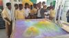
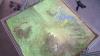
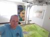
Recently, associate director of the Center for GIS, Tony Giarrusso, traveled to Karisoke to assemble and install the “Virtual Virungas” exhibit as part of a 50th anniversary retrospective of Dian Fossey, the pioneer of mountain gorilla field research in Rwanda. Funded by a Smithgall-Watts grant from the School of Biology, the “Virtual Virungas” is an immersive, four-dimensional visualization of mountain gorilla habit and ranging data, projected onto a bed of sand and operated through a variety of high-tech controls and input. Created by CGIS and IMAGINE Lab researchers, Matt Swarts, Noah Posner, and Giarrusso, the "Virtual Virungas" sandbox uses historic mountain gorilla ranging data plus satellite imagery, topographic maps, and other geo-referenced, spatio-temporal data to show how the gorilla groups have ranged during different periods of time. Visitors can even modify what is shown on the sand through their mobile phones or computers. Exhibit tours for local secondary school and university students, conservation officials and tourists are conducted during weekdays by Karisoke staff members.
Initial reviews of the exhibit have been outstanding. Karisoke Director of IT, Jules Abiyingoma, recently gave four tours to local high school students and said this about his and their experiences with the virtual sandbox: “This sand box technology is amazing! I had four demos yesterday for four different schools and it all went smoothly. Everyone loved it and the students did not want to leave that section. They asked so many questions about gorillas, the park and the technology itself. Ironically they were so quiet during the previous sections of the tour and when they reached the sand box, they came to life! And started asking even questions related to previous sections. It's as if the sandbox awakes them from a deep sleep!”
In addition to installing the virtual sandbox, Mr. Giarrusso held GIS training sessions for Karisoke staff members, which included an MS GIS student from the MS GIS program at the National University of Rwanda in Butare, Rwanda. Topics covered included geocoding animal observation data, analyzing animal movements, and basic computer practices.
Mr. Giarrusso was also fortunate enough to obtain a tourist permit to visit the mountain gorillas. He visited the group, Isabukuru, one of the DFGFI mountain gorilla research groups he has mapped, and was able to see more than 10 mountain gorillas in the wild, including a set of identical twins born in early 2016. It was an experience he said he will never forget and hopes to repeat again. He expects to return to Karisoke in 2017 to update the virtual sandbox and conduct a weeklong, more formal GIS training session for Karisoke staff.
Summary
CGIS researcher Tony Giarrusso recently installed a “Virtual Sandbox” in Rwanda where CGIS has been working with the Dian Fossey Gorilla Fund International for more than 10 years.
Groups
Status
- Workflow Status:Published
- Created By:Tony Giarrusso
- Created:07/11/2016
- Modified By:Fletcher Moore
- Modified:10/07/2016
Categories