news
Scientists Assess Flooding and Damage from 2008 Myanmar Cyclone
Primary tabs
Tropical Cyclone Nargis made landfall in the Asian nation of Myanmar on May 2, 2008, causing the worst natural disaster in the country's recorded history -- with a death toll that may have exceeded 138,000. In the July 2009 issue of the journal Nature Geoscience, researchers report on a field survey done three months after the disaster to document the extent of the flooding and resulting damage.
The information -- which may be the first reliable measurements of cyclone damage in the area -- could lead to development of computer models for predicting how future storms may impact the geologically complex Ayeyarwady River delta. Those models could be the basis for planning, construction and education that would dramatically reduce future loss of life.
Among the findings of the study: the cyclone created a storm surge as much as five meters high -- topped by two-meter storm waves -- that together inundated areas as much as 50 kilometers inland. Fatality rates reached 80 percent in the hardest-hit villages, and an estimated 2.5 million people in the area lived in flood-prone homes less than 10 feet above sea level.
"The recorded high water marks serve as benchmarking for numerical models for the complex hydraulic response of the giant Ayeyarwady delta," noted Hermann M. Fritz, an associate professor in the School of Civil and Environmental Engineering at the Georgia Institute of Technology. "Ongoing numerical simulations will allow us to determine flood zones and vulnerabilities for future cyclone scenarios. Based on those, evacuation scenarios and evaluation plans will be derived in collaboration with international partners and the Myanmar government."
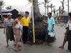
Already, a local non-governmental organization in the nation has developed a cyclone education program to raise awareness among residents, said Fritz, who was the only international scientist leading a team that surveyed 150 kilometers of the country's coastline during a two-week period August 9-23, 2008.
"The aim of our project was to document the extent of the flooding and associated damage in the delta," Fritz explained. "Field surveys in the immediate aftermath of major disasters focus on perishable data, which would otherwise be lost forever -- such as infrastructure damage prior to repair and reconstruction."
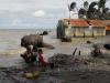
In the flood zone, for instance, the researchers searched for evidence of water marks on buildings, scars on trees and rafted debris as indicators of the maximum water height.
"Nargis washed away entire settlements, often without leaving a single structure standing, which forced us to focus on evidence left on large trees," added Fritz, who has studied other natural disasters in Asia, Africa and the United States. "High water marks were photographed and located using global positioning system instruments. Transects from the nearest beach or waterway to the high water marks were recorded with a laser range finder."
The survey team documented soil erosion of as much as one meter vertically and more than 100 meters horizontally. Highlighting the loss of land was a golden Buddhist stupa -- originally constructed on dry land -- that was left 150 meters offshore following the storm. Cyclone Nargis also scoured several drinking water wells, leaving them in the beach surf zone -- and depriving survivors of safe water supplies.
While the storm surge and waves weren't unusually high, the impact may have been worsened by the lack of nearby high ground for evacuation and loss of coastal mangrove forests that could have slowed the storm waves, Fritz said. Structures in the area were not built to survive cyclones, and there was no evacuation plan for the area -- where people had no previous experience with such storms.
Those finding point to recommendations, including implementation of a cyclone education program, development of flood and vulnerability maps, construction of cyclone-safe buildings to serve as shelters, implementation of an improved warning system, and planning for evacuation, Fritz said. Partial reconstruction of the mangroves that had been removed for agriculture and fuel could also help protect the coastline.
The expedition's itinerary was planned based on unofficial damage reports, physical storm and cyclone track data, satellite imagery, numerical model benchmark requirements and experience gained in surveying other disasters. The group traveled to the country by cargo boat and did most surveying from the vessel.
The research was in part supported by the Pyoe Pin Programme of the Department for International Development in the United Kingdom. The program is also sponsoring detailed modeling and a follow up study being done at Georgia Tech by Fritz and Christopher Blount, one of his doctoral students.
A Category 4 storm, Nargis was the eighth deadliest cyclone recorded worldwide. It is one of seven tropical cyclones generated in the Bay of Bengal that had death tolls in excess of 100,000. With damage estimated at more than $10 billion, the storm is the most destructive ever recorded in the Indian Ocean.
Fritz hopes the work done by the survey team -- which also included Swe Thwin of the Myanmar Coastal Conservation Society and Moe Kyaw and Nyein Chan of the Mingalar Myanmar NGO -- will ultimately help reduce the human cost of major cyclones.
"In the 21st century with modern communication and all that has been learned about cyclones in the Bay of Bengal, there is no need for 138,000 people to be killed by a storm like this," Fritz said. "With adequate planning, education and shelters, it should be possible to reduce fatality rates from future cyclones by at least one order of magnitude."
Research News & Publications Office
Georgia Institute of Technology
75 Fifth Street, N.W., Suite 100
Atlanta, Georgia 30308 USA
Media Relations Contacts: John Toon (404-894-6986); E-mail: (jtoon@gatech.edu) or Abby Vogel (404-385-3364); E-mail: (avogel@gatech.edu).
Writer: John Toon
Summary
Groups
Status
- Workflow Status:Published
- Created By:John Toon
- Created:07/16/2009
- Modified By:Fletcher Moore
- Modified:10/07/2016
Categories
Keywords